Seven-step approach for complete near-surface resistivity survey of farmland with LandMapper.
Despite numerous EC-mapping case studies conducted in many countries, only a few studies have demonstrated a complex approach to electrical geophysical site survey. In most studies only one technique of EC-mapping, either EM, GPR or four-electrode method was employed. This is understandable since most commercially available EC/ER measuring equipment operate in limited range of resistivities and depths (1-2 manufacturer-set depths are typical)... Read More>>
Setting up RES2DINV/RES3DINV (DEMO ver.) for the first time.
Download DEMO 32-bit version of RES2DINV and RES3DINV from attached files below this post or download DEMO versions of RES2DINV and RES3DINV. Supplemental publications and other versions of software (legacy or 64-bit) are available for registered users from the respective folders (RES2DINV and RES3DINV) under SUPPORT/Downloads section of this website. You have to login before you can acces the Downloads repository (see more here)
Note, that you can use RES2DINV without RES3DINV, but not other way around - RES2DINV have to be installed first. This demo software has decreased functionality, but it might be enough for your research and the DEMO versions never expire.
However, if you decide to purchase software, please request a formal quote from us ASAP before contacting GEOTOMO directly, as we will meet or beat price of other dealers, but we cannot guarantee it unless you secure order from us first... Read more>>
Getting started with 2D resistivity interpretation using RES2DINV

Presentation, embedded below was developed to bring users up to speed in interpretation of their resistivity data. Class for end users was conducted in Indonesia and included training on field data collection with SibER-48 using ~ 900 m long profile in Wenner-Schlumberger and pole-dipole (remote electrode) 2D tomography. On the second day users received hands-on instructions on data import into RES2DINV software, quality assurance of the data based on visual approach as well as through RMS of the interpretation model... Read More>>
2D Dipole-Dipole Electrical Tomography with LandMapper
Manual measuring of electrical resistivity 2D cross-section is possible with LandMapper with supplied (optional) or made by user cable set.
There are two modifications of 2D cable set offered and tested by Landviser, LLC:
- Mobile shallow (~2 m depth) set consisted of two T-style probes (AB and MN dipoles) similar to mapping probes. The dipoles are set at 1 m size with possible separation between dipoles (wire length) no more than 5 meters (n=5)
- Stationary set (~ 14 m depth) where electrodes are hammered on the soil surface along the straight line at one meter distance. Electrodes are simple metal spikes/nails and is sourced locally (are NOT provided by Landviser, LLC). We supply wires with banana-plug connections to LandMapper terminals on one end and alligator clips on the other end to connect with electrodes... Read More>>
Formatting Array Input Data File in RES2DINV: surface electrodes for any geometry

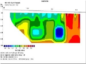
Example of electrodes arrangement and measurement sequence that can be used for a 2-D electrical imaging survey is shown on the left. Many different multi-electrode systems have been developed over the past 15 years using different arrangements of the cables and measurement strategies (Loke, 2011). This program is designed to invert large data sets (with about 200 to 100000 data points) collected with a system with a large number of electrodes (about 25 to 16000 electrodes). The survey is usually carried out with a system where the electrodes are arranged along a line with a constant spacing between adjacent electrodes. However, the program can also handle data sets with a non-uniform electrode spacing. RES2DINV program can be used for surveys using the Wenner, pole-pole, dipole-dipole, pole-dipole, Wenner-Schlumberger, gradient and equatorial dipole-dipole (rectangular) arrays. In addition to these common arrays, the program even supports non-conventional arrays with an almost unlimited number of possible electrode configurations (Loke et al. 2010). You can process pseudo sections with up to 16000 electrode positions and 70000 data points at a single time on a computer with 4 gigabytes (GB) of RAM. Besides normal surveys carried out with the electrodes on the ground surface, the program also supports aquatic and cross-borehole surveys... Read More>>