- We have a few new models of LandMappers in stock in USA and Europe!
- Please, CONTACT US to discuss the suitability of LandMapper ERM-03 or ERM-04 for your applications.
We offer a full range of geophysical instruments and software:
|
|---|
Want to learn more? We explain complex technologies in simple terms!
Register at our Geo-Tech Support Portal @ https://in.landviser.xyz
You can even install our Support App for iOS or Android from the link above!

On-the-go sensors, designed to measure soil electrical resistivity (ER) or electrical conductivity (EC) are vital for faster non-destructive soil mapping in precision agriculture, civil and environmental engineering, archaeology and other near-surface applications. Compared with electromagnetic methods and ground penetrating radar, methods of EC/ER measured with direct current and four-electrode probe have fewer limitations and were successfully applied on clayish and saline soils as well as on highly resistive stony and sandy soils. However, commercially available contact devices, which utilize a four-electrode principle, are bulky, very expensive, and can be used only on fallow fields. Multi-electrode ER-imaging systems applied in deep geophysical explorations are heavy, cumbersome and their use is usually cost-prohibited in many near-surface applications, such as forestry, archaeology, environmental site assessment and cleanup, and in agricultural surveys on farms growing perennial horticultural crops, vegetables, or turf-grass. In such applications there is a need for accurate, portable, low-cost device to quickly check resistivity of the ground on-a-spot, especially on the sites non-accessible with heavy machinery.
Four-electrode principle of EC/ER measurements
Our equipment utilizes well-known four-electrode principle to measure electrical resistivity or conductivity (Fig).
LandMapper® measures the potential difference (dV) that arises between two electrodes (M and N), when electrical current (I) is applied to the other two electrodes (A and B). The increase of the distance among four electrodes in a set allows measuring the resistivity of the deeper layers, f.e. the probe of A2M2N2B2 reaches deeper than A1M1N1B1 (Fig). In theory, the electrical resistivity (ER) of a material is defined as follows: 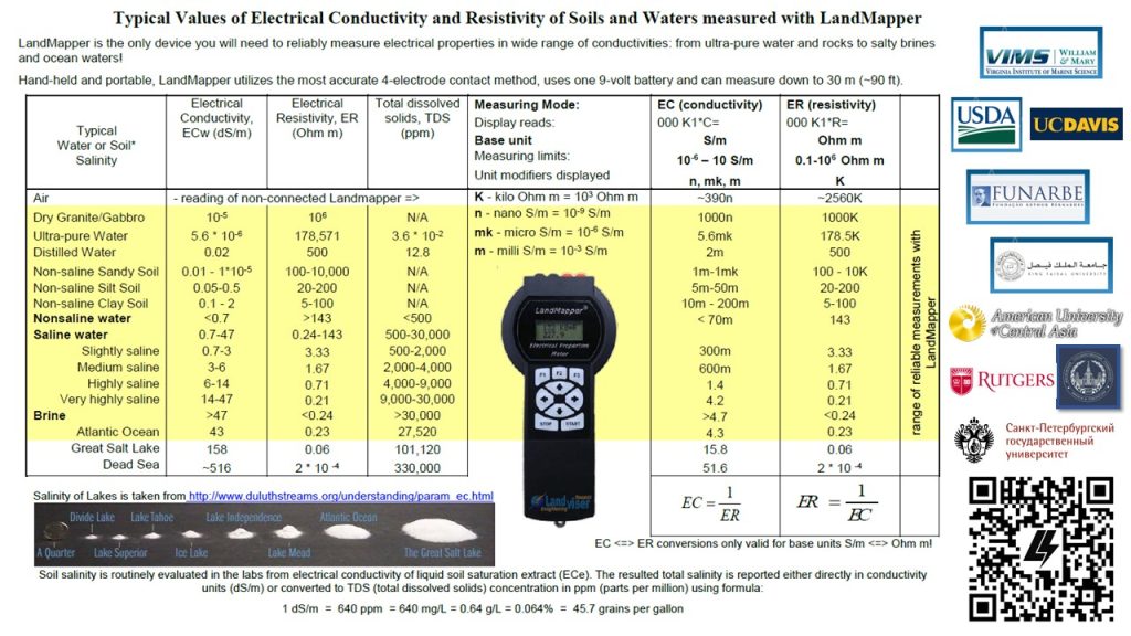
where L is the length of a uniform conductor with a cross-sectional area A. A/L is a geometrical coefficient (K), which is easily calculated for different in-situ electrode arrangements and laboratory conductivity cells. LandMapper® calculates electrical resistivity using the Ohm’s Law.
The direct digital output of the device is electrical resistivity (ER) in Ohm m. Those can be converted automatically in electrical conductivity (S/m) inside LandMapper® ERM-02/-04 by using the reciprocal of the measured resistivity: EC=1/ER.
Thus, the measured results may as well be presented in convenient for soil scientists form of soil electrical conductivity (EC), which is routinely used to evaluate salinity of soils and irrigation water. However, EC can be used in many more applications than just soil salinity! Also, ERM-02 can output natural electrical potential (EP) of soil and plants, which has some specific applications in hydrology, civil engineering, forestry, and biology.
Applications of EC/ER technology in soil studies

Mapping of soil properties highly influencing density of mobile electrical charges (measured EC/ER strongly correlates with those properties in-situ):
- Soil salinity
- Soil texture (i.e. silt, sand and clay contents, the working formula needs to be developed)
- Coarse fragment content and depth to bedrock
- Depth to limiting layers like clay and plow pan (wastewater – leaching fields)
- Groundwater depth – capillary rise extent in profile
- Correlations between soil EC maps and yield maps for many crops were established
- Depth and extent of permafrost.
- Pollution detection – depth and limits (pollution during oil and gas mining, for example)
- Location and stability of karsts and carbonate sinkholes.
- Mapping of soil disturbance and search for hidden objects (drainage pipes, urban underground communications, forensic and archaeological applications).
- Estimating depth of peat deposits during prospecting and locating methane accumulations in natural bogs and swamps.
Monitoring processes where only one soil property is changing:
12. Soil water content changes
13. Monitoring fertilizer uptake and other solute transport in soils (f.e. during phytoremediation)
14. Monitoring of freezing-melting processes in soil
15. Mapping and monitoring leakage from the retention ponds and sewage ponds, and underground oil storage tanks.
Applications in soil genesis studies:
Many soils of humid areas developed under downward leaching and typically feature the eluvial horizon with very high resistivity.
16. The thickness of horizons, the degree of eluviations and soil profile organization can be evaluated either without digging soil pits or by quick checking EC on the walls of soil pits.
17. Measuring of soil vertical and horizontal anisotropy non-destructively.
Special applications beyond soil studies:
18. Forestry – in addition to evaluating all-important soil properties of forest soils, monitoring ER of a growing tree can indicate wood quality and if the plant is stressed (also electrical potential is especially useful in plant health studies as non-penetrating electrodes can be mounted on the surface of herbaceous plants).
19. Evaluating and monitoring the stability of the roads (seasonal, gravel, asphalt, on permafrost or landslides, etc.).
20. Measuring integrity of underground electrical cables and pipes (and soil corrosive properties).
21. Monitoring charge-recharge processes in membrane resins in water purification plants or consumer distillers.
Richard Feynman once said: “There is not a single phenomenon in Nature which is not driven by electricity to some extent. ” (quote paraphrased). Richard Feynman (1918-88) had an enormous talent of explaining complicated scientific matters to non-scientists. Watch this short video where he admires wonders of electricity in the dentist’s waiting room – “Electricity is bigger than gravity!”
###################
22. ….? Can you think of any other possible applications that can benefit if the electrical conductivity/potential of a natural system could be measured quickly and non-destructively?
We at Landviser would like to hear from you!
Leave a Reply
You must be logged in to post a comment.