• Skip to primary navigation
  • Skip to main content
  • Skip to footer
Landviser

Landviser

Enlightening Research

  • About
    • USA
    • EUROPE
    • RUSSIA
    • Partners
  • LandMapper
    • map Golf Courses
    • FIND treasure
    • locate burials
  • Products
    • Electrical Resistivity Instruments
    • LandMapper
      • Previous Models
    • SibER
    • AEMP-14
    • RTK GPS
    • Software
      • RES2DINV
      • RES3DINV
      • Download and Install RES2DINV or RES3DINV
  • Solutions
    • Agriculture
    • Soil Science
    • Environmental Science
    • Hydrology
    • GIS
      • Maps-N-Memories
      • Flood of epic proportions in South TX
      • Irma First Response Live Map
  • Sale
  • Blog
  • DIY
    • Build EC mapping probe
    • Calibrate lab EC cell
    • EC Mapping with LandMapper and Phone GPS
    • GPX to KML to Excel | Lat-Long data transformation
    • 1D VES – Vertical Electrical Sounding
    • 2D Electrical Tomography
    • Self Potential Mapping Procedure
  • CONTACT
    • FAQs
    • Support
    • Larisa Golovko
  • en English
    af Afrikaanssq Albanianam Amharicar Arabichy Armenianaz Azerbaijanieu Basquebe Belarusianbn Bengalibs Bosnianbg Bulgarianca Catalanceb Cebuanony Chichewazh-CN Chinese (Simplified)zh-TW Chinese (Traditional)co Corsicanhr Croatiancs Czechda Danishnl Dutchen Englisheo Esperantoet Estoniantl Filipinofi Finnishfr Frenchfy Frisiangl Galicianka Georgiande Germanel Greekgu Gujaratiht Haitian Creoleha Hausahaw Hawaiianiw Hebrewhi Hindihmn Hmonghu Hungarianis Icelandicig Igboid Indonesianga Irishit Italianja Japanesejw Javanesekn Kannadakk Kazakhkm Khmerko Koreanku Kurdish (Kurmanji)ky Kyrgyzlo Laola Latinlv Latvianlt Lithuanianlb Luxembourgishmk Macedonianmg Malagasyms Malayml Malayalammt Maltesemi Maorimr Marathimn Mongolianmy Myanmar (Burmese)ne Nepalino Norwegianps Pashtofa Persianpl Polishpt Portuguesepa Punjabiro Romanianru Russiansm Samoangd Scottish Gaelicsr Serbianst Sesothosn Shonasd Sindhisi Sinhalask Slovaksl Slovenianso Somalies Spanishsu Sudanesesw Swahilisv Swedishtg Tajikta Tamilte Teluguth Thaitr Turkishuk Ukrainianur Urduuz Uzbekvi Vietnamesecy Welshxh Xhosayi Yiddishyo Yorubazu Zulu

Calibrate (calculate) K-coefficient for laboratory four-electrode cell

You are here: Home / Equipment / DIY / Calibrate (calculate) K-coefficient for laboratory four-electrode cell

February 8, 2013 By Landviser

Laboratory cells supplied by Landviser, LLC have been calibrated and the respective K-geometric coefficient is printed on the cell. The cells have to be filled to the top rim, in order for the coefficient to be accurate. Also, sometimes due to corrosion of conductive plates (electrodes) the coefficient of the cell might change slightly. Thus, you can verify K-coefficient of any cell, just follow instructions below.

For other tips, download Measuring Properties of Natural Systems with LandMapper ERM-02 (manual)

Materials:

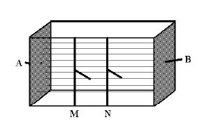
Fig. Scheme of the four-electrode laboratory conductivity cell. Electrical field lines are shown with thin straight lines (uniform electrical field).
  1. Laboratory cell with embedded four-electrodes
  2. Distilled water and standard resistivity solution (f.e. from Fisher Scientific, Inc.)
  3. LandMapper with four banana plugs to alligator clips connectors.

Procedure:

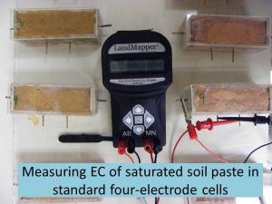
  1. Connect LandMapper to electrodes embedded in the cell. Landviser’s supplied rectangular cells have current (AB) electrodes as metal plates at the end of rectangular prism and potential (MN) electrodes as wire lines embedded on the front. Connect LandMapper terminals accordingly.
  2. Fill cell with standard solution (ERss=X) with known resistivity. Measure ER on K0=1.
  3. Record measured resistivity ERm=Y.
  4. Measured ER times cell K-coefficient should be equal ERss:

                                                  ERss=K*ERm

Therefore, K of the cell is equal ERss divided by ERm:

K= ERss/ERm

  1. Verify with distilled water (ER ~ 1000 Ohm m) or other standard resistivity solution.

Location

USDA-ARS Washington D.C., MD 38° 53' 42.4032" N, 77° 2' 10.9176" W
See map: Google Maps

Filed Under: DIY, Equipment, Geophysical equipment, Geophysics, LandMapper, Soil Science

Footer

CONNECT WITH US

Solutions

  • Equipment
  • Software
  • Analytics
  • Maps

Products

  • LandMapper
  • SibER
  • AEMP-14
  • RES2DINV / RES3DINV
  • RTK GPS
2008-2021 (c) Landviser, LLC. Powered by JetRank Agency
en English
af Afrikaanssq Albanianam Amharicar Arabichy Armenianaz Azerbaijanieu Basquebe Belarusianbn Bengalibs Bosnianbg Bulgarianca Catalanceb Cebuanony Chichewazh-CN Chinese (Simplified)zh-TW Chinese (Traditional)co Corsicanhr Croatiancs Czechda Danishnl Dutchen Englisheo Esperantoet Estoniantl Filipinofi Finnishfr Frenchfy Frisiangl Galicianka Georgiande Germanel Greekgu Gujaratiht Haitian Creoleha Hausahaw Hawaiianiw Hebrewhi Hindihmn Hmonghu Hungarianis Icelandicig Igboid Indonesianga Irishit Italianja Japanesejw Javanesekn Kannadakk Kazakhkm Khmerko Koreanku Kurdish (Kurmanji)ky Kyrgyzlo Laola Latinlv Latvianlt Lithuanianlb Luxembourgishmk Macedonianmg Malagasyms Malayml Malayalammt Maltesemi Maorimr Marathimn Mongolianmy Myanmar (Burmese)ne Nepalino Norwegianps Pashtofa Persianpl Polishpt Portuguesepa Punjabiro Romanianru Russiansm Samoangd Scottish Gaelicsr Serbianst Sesothosn Shonasd Sindhisi Sinhalask Slovaksl Slovenianso Somalies Spanishsu Sudanesesw Swahilisv Swedishtg Tajikta Tamilte Teluguth Thaitr Turkishuk Ukrainianur Urduuz Uzbekvi Vietnamesecy Welshxh Xhosayi Yiddishyo Yorubazu Zulu