• Skip to primary navigation
  • Skip to main content
  • Skip to footer
Landviser

Landviser

Enlightening Research

  • About
    • USA
    • EUROPE
    • Partners
  • LandMapper
    • helps farmers
    • maps Golf Courses
    • helps civil engineers
    • grounds safely
    • FINDs treasure
    • locates burials
  • Equipment
    • Electrical Resistivity Instruments
    • LandMapper: RES/EC/SP Handheld
      • Previous Models
    • SibER: RES/IP Subsurface Imaging
    • AEMP-14: Multi-frequency EM Scanner
    • GEOVIZER: ergonomic EM scanner
    • RTK GPS
  • Software
    • RES2DINV and RES3DINV Geophysical Software
  • Solutions
    • Agriculture
    • Environmental Science
    • GIS Portal
    • Subsurface Mapping in 3D with Geophysics
  • Blog
  • DIY
    • Calibrate lab EC cell
    • Make four-electrode probe for soil mapping
    • EC Mapping with LandMapper and Phone GPS
    • GPX to KML to Excel | Lat-Long data transformation
    • 1D VES – Vertical Electrical Sounding
    • 2D Electrical Tomography
    • Self Potential Mapping Procedure
  • CONTACT
    • FAQs
    • Support
    • Larisa Golovko
  • Sale
  • en English
    af Afrikaanssq Albanianam Amharicar Arabichy Armenianaz Azerbaijanieu Basquebe Belarusianbn Bengalibs Bosnianbg Bulgarianca Catalanceb Cebuanony Chichewazh-CN Chinese (Simplified)zh-TW Chinese (Traditional)co Corsicanhr Croatiancs Czechda Danishnl Dutchen Englisheo Esperantoet Estoniantl Filipinofi Finnishfr Frenchfy Frisiangl Galicianka Georgiande Germanel Greekgu Gujaratiht Haitian Creoleha Hausahaw Hawaiianiw Hebrewhi Hindihmn Hmonghu Hungarianis Icelandicig Igboid Indonesianga Irishit Italianja Japanesejw Javanesekn Kannadakk Kazakhkm Khmerko Koreanku Kurdish (Kurmanji)ky Kyrgyzlo Laola Latinlv Latvianlt Lithuanianlb Luxembourgishmk Macedonianmg Malagasyms Malayml Malayalammt Maltesemi Maorimr Marathimn Mongolianmy Myanmar (Burmese)ne Nepalino Norwegianps Pashtofa Persianpl Polishpt Portuguesepa Punjabiro Romanianru Russiansm Samoangd Scottish Gaelicsr Serbianst Sesothosn Shonasd Sindhisi Sinhalask Slovaksl Slovenianso Somalies Spanishsu Sudanesesw Swahilisv Swedishtg Tajikta Tamilte Teluguth Thaitr Turkishuk Ukrainianur Urduuz Uzbekvi Vietnamesecy Welshxh Xhosayi Yiddishyo Yorubazu Zulu

Geophysical Instruments and Field Equipment

Expanding geophysical instruments and software offerings in 2022!

You are here: Home / Geophysical Instruments and Field Equipment
News
Downloads
YouTube
Learn More
News
  • We have a few new models of LandMappers in stock in USA, Russia, and Europe!
  • Please, CONTACT US by registering at our Geo-Tech Support Portal – Landviser – Login – to discuss the suitability of LandMapper or other instruments for your applications.
Downloads
  • Landviser: new products 2021 one page brochure
  • Landviser: overview of company offering slides of presentation 2021
  • SiberGeo and TerraZond full equipment catalog
YouTube
Landviser’s YouTube Channel
We offer a full range of geophysical instruments and software:
  • Versatile field EC/RES/SP devices – LandMappers;
  • Electromagnetic scanners (AEMP-14 and Geovizer);
  • Deep & fast Electrical Tomography RES/IP instruments (SibER-32, -48, -64);
  • Multifrequency 3D  Ground Penetrating Radar (GRT-2X GPR – TerraZond);
  • RTK GPS/GLONASS receivers;
  • RES2DINV / RES3DINV and Aarhus Workbench Geo software
Contact us for advice on YOUR surveying project needs! Don’t get lost in details!
Learn More

Want to learn more? We explain complex technologies in simple terms!

Register at our Geo-Tech Support Portal @ https://in.landviser.xyz

You can even install our Support App for iOS or Android from the link above!

NEW and improved:

  • LandMapper – RES/EC/SP handhelds,
  • faster multi-channel SibER-64k15 and -48k12 – RES/IP deep tomography sets,
  • ergonomic 3-frequency Geovizer – EM scanner,
  • ride-on TerraZond – multi-frequency GPR and cloud decision support for geoscientists and civil engineers…

 Contact Us

LandMapper ERM-03 -04

Accuracy>99%

Safe & reliable standard:
9 V battery

PC connected for data transfer

LandMapper ERM-03

New hand-held geophysical device (field-rigged enclosure, ergonomic design) measuring electrical resistivity & conductivity (RES/EC). 

Includes: field bag, lanyard, USB cable, user manual, USB drive with software and info

LandMapper ERM-04

All of the above + accurate measurement of natural electrical fields (self-potential, SP) in soils and plants via non -polarizing electrodes.

SibER ( -32k4, -48k12, -64k15 )

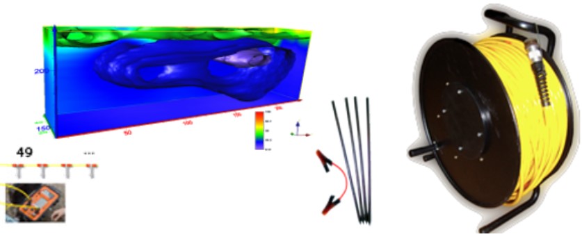
Powerful and accurate multi-electrode tomography instrument for resistivty and induced polarization (RES/IP) reaching 300+ m below. Cables with spacings of 1 to 20 m are available.

RES2DINV & RES3DINV

Software for robust and fast 2D/3D inversion of Resistivity/IP data.

Free DEMO

Low-frequency EM Scanners

AEMP-14

Multi-frequency (14 user-
defined frequencies 2.5
to 250 kHz) electro-
magnetic scanner for
fast non-contact imaging
of top 8-m profiles

GEOVISER

Three frequency for fast mapping of key depth layers within top 3 m Ergonomic design Android software to view subsurface in the field

Ground radio tomography GRT-2X (3D GPR)

Multi-frequencies (0.5-2 GHz)
Modular design: (8-32 antennas)
  • Scan width (0.7-2.7 m)
  • Scan depth up to 3 m
  • Scan accuracy <7.5 mm

GPS/ Glonass

Spraying, Delivery, Imagery & Geophysical UAVs

R&D, Sales, Rental and Training on UAV
in collaboration with Hylio (USA) and
SiberGeo (Estonia)

Landviser R&D (USA and EU)

– Continues R&D to improve LandMapper ® and other geophysical instruments;
– Develops geo-enabled interactive web maps and apps;
– Provides custom system integrations and BI analytics (GIS, Image analysis, Big Data, AI, ML, IoT) of geospatial data across industries.
– Develops custom software solutions (Python scripting, desktop/server/ web/mobile platforms) in temporal/spatial analysis for agriculture, environmental science, climatology and meteorology.
Let’s talk about your application!

In addition to its own equipment, Landviser also distributes and consults worldwide for:
– geophysical equipment of GeoDevice, SiberGeo, and TerraZond (EU);
– accurate geo-positioning systems hardware (DGPS, RTK GPS/GLONASS) of various vendors;
– specialized UAV (Drones) integrated with various payloads;
– geophysical software for Geotomosoft Solutions (Malaysia), Aarhus GeoSoftware (Denmark), and Bentley-Seequent

Our Partners:

Footer

Landviser - Enlightening Research

CONNECT WITH US

Solutions

  • Equipment
  • Software
  • Analytics
  • Maps

Products

  • LandMapper
  • SibER
  • AEMP-14
  • RES2DINV / RES3DINV
  • RTK GPS
2008-2021 (c) Landviser, LLC. Powered by JetRank Agency
en English
af Afrikaanssq Albanianam Amharicar Arabichy Armenianaz Azerbaijanieu Basquebe Belarusianbn Bengalibs Bosnianbg Bulgarianca Catalanceb Cebuanony Chichewazh-CN Chinese (Simplified)zh-TW Chinese (Traditional)co Corsicanhr Croatiancs Czechda Danishnl Dutchen Englisheo Esperantoet Estoniantl Filipinofi Finnishfr Frenchfy Frisiangl Galicianka Georgiande Germanel Greekgu Gujaratiht Haitian Creoleha Hausahaw Hawaiianiw Hebrewhi Hindihmn Hmonghu Hungarianis Icelandicig Igboid Indonesianga Irishit Italianja Japanesejw Javanesekn Kannadakk Kazakhkm Khmerko Koreanku Kurdish (Kurmanji)ky Kyrgyzlo Laola Latinlv Latvianlt Lithuanianlb Luxembourgishmk Macedonianmg Malagasyms Malayml Malayalammt Maltesemi Maorimr Marathimn Mongolianmy Myanmar (Burmese)ne Nepalino Norwegianps Pashtofa Persianpl Polishpt Portuguesepa Punjabiro Romanianru Russiansm Samoangd Scottish Gaelicsr Serbianst Sesothosn Shonasd Sindhisi Sinhalask Slovaksl Slovenianso Somalies Spanishsu Sudanesesw Swahilisv Swedishtg Tajikta Tamilte Teluguth Thaitr Turkishuk Ukrainianur Urduuz Uzbekvi Vietnamesecy Welshxh Xhosayi Yiddishyo Yorubazu Zulu