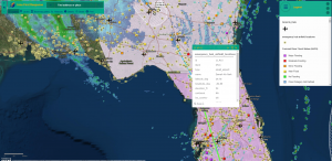
http://arcg.is/1rzDHq Map has 3 zoom levels. Map in the header shows current status of roads and traffic: closure, delay, etc with markers and pop-ups on what was reported. Live feed from Waze users. Also shows locations of major airports and small airports / landing strips. Pop-ups show airport name, contact phone, Lat-Log and codes.
When zooming out – traffic info from Waze would not display, only airports (big and small):
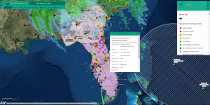
Final zoom to the all area only displays projected and occurred path of current storm (Irma and Jose), weather radar (precipitation), big airports, flooding gauges markers and area prone to flooding:
That’s all so far.