Geovizer is so light, it could be mounted on a Drone!
We presented “Novel Flying EM Sensor for Agricultural Research” at Summit on Drone Geophysics – November 2-5, 2021.
#EMGeoDrone sensor being developed by SiberGeo and Landviser: Enlightening Research on GeoData (EMGeoDrone sensor was developed with the support of EU HORIZON 2020 research and innovation program, PARSEC Consortium, under grant agreement #824478 “Crop Predictions Take Flight – Linking Genomics and Geophysics”)
Software Downloads
- Android APK – QZOND (we will send you link and instructions on how to install on your own device) – Geovizers purchased through us come with unlocked Android device with QZond software preloaded.
- iiSystem – PC software Zip (download, unzip, and run on your PC)
We offer a full range of geophysical instruments and software:
|
|---|
Want to learn more? We explain complex technologies in simple terms!
Register at our Geo-Tech Support Portal @ https://in.landviser.xyz
You can even install our Support App for iOS or Android from the link above!

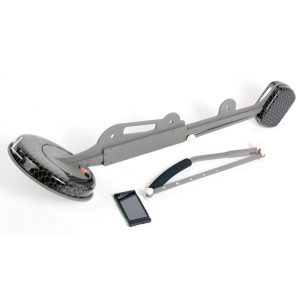
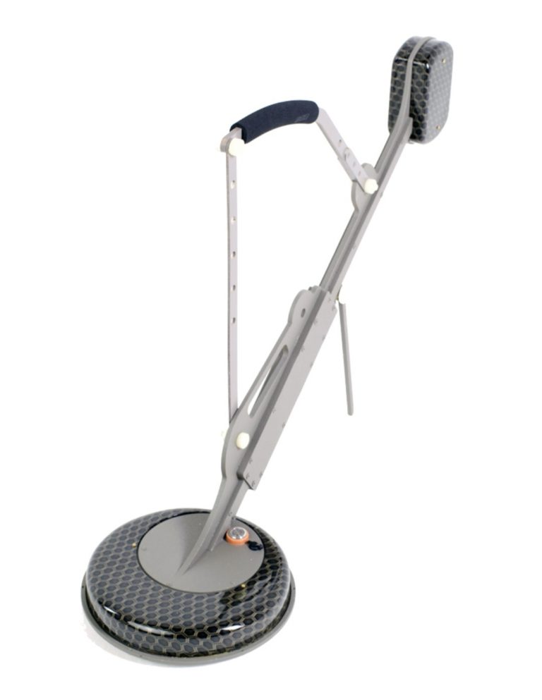
Electromagnetic 3-frequency sounding device Geovizer
Geovizer designed to study the top three meters of the Earth’s crust. The real depth of measurement depends on the resistivity of the ground, however, can’t exceed 3 m on real ground because of the limited sensitivity of receivers.
Meanwhile, we can expect that in some special kinds of media such as dry sands or ice the propagation depth can reach and even exceed 4 m.
The device can operate on 3 frequencies. It means that the data acquired can describe the geoelectric situation at 3 levels of depth.
In the horizontal plane, the responding media is the ellipse with one constant axis length (0.7 m) and second axis length depending on the frequency 0.5 –3 m.
Having such a resolution we can basically state that the unit is intended for 3D specification of geoelectrical parameters of the media at a depth up to 3 meters with heterogeneous inclusions dimensions 0.5 x 0.5 x 1 m or more. Meanwhile, the very contrast targets such as metal objects can be even smaller.
Applications of Geovizer:
- Archaeological survey;
- UXO determination;
- Subsurface tunnels and empties investigations;
- Quantitative assessment of water saturation of the ground;
- Assessment of HC waste in the ground;
- Searching both fresh and salty water source;
- Subsurface buildings condition control;
- Searching and localization of burial place of industrial waste;
- Source and volumes of water leakage in water supply and heating systems;
- Source and volumes of fuel/oil leakage in subsurface fuel tanks/pipelines;
- Definition of places of a lining of metal pipes and cables.
Fill the form below to receive technical documentation instantly
Technical specifications
- Frequency range: 12.5-111 kHz;
- Transmitter power (impulse): 60 W;
- Receiver sensitivity: 1 mV;
- Scan time for a single point at 3 freqs: 2 sec (or any set from 1-14 deferent frequencies);
- Noise level: 50 nV;
- Dimensions: 90х75х25 cm
- Battery operation time: 8 hours;
- Weight: 5 kg.