• Skip to primary navigation
  • Skip to main content
  • Skip to footer
Landviser

Landviser

Enlightening Research

  • About
    • USA
    • EUROPE
    • RUSSIA
    • Partners
  • LandMapper
    • FIND treasure
    • Agriculture
    • Hydrology
  • Products
    • LandMapper
      • Previous Models
    • SibER
    • AEMP-14
    • RTK GPS
    • Software
      • RES2DINV
      • RES3DINV
      • Download and Install RES2DINV or RES3DINV
  • Solutions
    • Soil Science
    • Environmental Science
    • GIS
      • Maps-N-Memories
      • Flood of epic proportions in South TX
      • Irma First Response Live Map
  • Sale
  • Support
    • Blog
    • FAQs
    • DIY Tips
      • Build four-electrode probe
      • 1D VES – Vertical Electrical Sounding
  • CONTACT
    • Larisa Golovko
  • en English
    af Afrikaanssq Albanianam Amharicar Arabichy Armenianaz Azerbaijanieu Basquebe Belarusianbn Bengalibs Bosnianbg Bulgarianca Catalanceb Cebuanony Chichewazh-CN Chinese (Simplified)zh-TW Chinese (Traditional)co Corsicanhr Croatiancs Czechda Danishnl Dutchen Englisheo Esperantoet Estoniantl Filipinofi Finnishfr Frenchfy Frisiangl Galicianka Georgiande Germanel Greekgu Gujaratiht Haitian Creoleha Hausahaw Hawaiianiw Hebrewhi Hindihmn Hmonghu Hungarianis Icelandicig Igboid Indonesianga Irishit Italianja Japanesejw Javanesekn Kannadakk Kazakhkm Khmerko Koreanku Kurdish (Kurmanji)ky Kyrgyzlo Laola Latinlv Latvianlt Lithuanianlb Luxembourgishmk Macedonianmg Malagasyms Malayml Malayalammt Maltesemi Maorimr Marathimn Mongolianmy Myanmar (Burmese)ne Nepalino Norwegianps Pashtofa Persianpl Polishpt Portuguesepa Punjabiro Romanianru Russiansm Samoangd Scottish Gaelicsr Serbianst Sesothosn Shonasd Sindhisi Sinhalask Slovaksl Slovenianso Somalies Spanishsu Sudanesesw Swahilisv Swedishtg Tajikta Tamilte Teluguth Thaitr Turkishuk Ukrainianur Urduuz Uzbekvi Vietnamesecy Welshxh Xhosayi Yiddishyo Yorubazu Zulu

Setting up RES2DINV/RES3DINV (DEMO ver.) for the first time

You are here: Home / Archaeology / Setting up RES2DINV/RES3DINV (DEMO ver.) for the first time

March 21, 2010 By Landviser

Download DEMO 32-bit version of RES2DINV and RES3DINV from Geotomo Software website   . You can also order a USB flash-drive from us with all Geotomo materials for a nominal fee + shipping and handling

Note, that you can use RES2DINV without RES3DINV, but not the other way around - RES2DINV have to be installed first. This demo software has decreased functionality, but it might be enough for your research and the DEMO versions never expire.
However, if you decide to purchase software, please request a formal quote from us ASAP before contacting GEOTOMO directly, as we will meet or beat price of other dealers, but we cannot guarantee it unless you secure order from us first.

Now, installing the software…
Click setup.exe and follow directions. When you run through set up series of questions, click OK to the question about dongle installation.
Setup will quit.

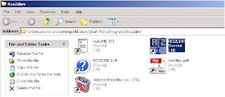
Then run the program from Start\Programs\RES2DINV or from the folder where it has been installed.

Without a dongle, you will see SemiDemo version. Click OK.
 

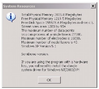
The big white screen will be there with menus on the top. If you see white screen only, probably the screen resolution on your PC system that makes it blown out of proportion. I did install mine on VISTA Ultimate 64-bit using the same file without any problem before, but today I happen to have Win XP 32-bit computer without RES2DINV, so I run setup.exe on it step by step and report it here. Works fine.

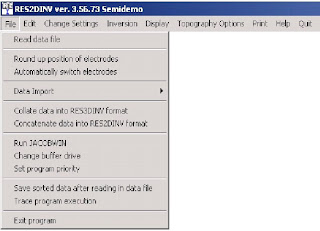
Go File/Run Jacobwin if you using a program for the first time. It will calculate partial derivatives for most popular arrays. You will not need to run it again ever on the same computer.

When you decided to purchase and receive your USB dongle in the mail, follow directions to install the dongle published in a manual book. You will not need to un-install DEMO versions, the software will pick up dongle if it attached otherwise it will continue to run in semi-demo mode.

If you run into any problems with installation, please, do not hesitate to contact Landviser, LLC or post a comment in this blog.

Filed Under: Archaeology, Civil Engineering, Environmental Science, Geophysics, Software, Subsurface imaging

Footer

Connect With Us

  • Email
  • Facebook
  • LinkedIn
  • Phone
  • Twitter
  • YouTube

Navigation

  • Equipment
  • Software
  • Consulting
  • Maps

Products

  • LandMapper
  • SibER
  • RES3DINV
  • GPS
Copyright © 2019. Powered by JetRank Agency
en English
af Afrikaanssq Albanianam Amharicar Arabichy Armenianaz Azerbaijanieu Basquebe Belarusianbn Bengalibs Bosnianbg Bulgarianca Catalanceb Cebuanony Chichewazh-CN Chinese (Simplified)zh-TW Chinese (Traditional)co Corsicanhr Croatiancs Czechda Danishnl Dutchen Englisheo Esperantoet Estoniantl Filipinofi Finnishfr Frenchfy Frisiangl Galicianka Georgiande Germanel Greekgu Gujaratiht Haitian Creoleha Hausahaw Hawaiianiw Hebrewhi Hindihmn Hmonghu Hungarianis Icelandicig Igboid Indonesianga Irishit Italianja Japanesejw Javanesekn Kannadakk Kazakhkm Khmerko Koreanku Kurdish (Kurmanji)ky Kyrgyzlo Laola Latinlv Latvianlt Lithuanianlb Luxembourgishmk Macedonianmg Malagasyms Malayml Malayalammt Maltesemi Maorimr Marathimn Mongolianmy Myanmar (Burmese)ne Nepalino Norwegianps Pashtofa Persianpl Polishpt Portuguesepa Punjabiro Romanianru Russiansm Samoangd Scottish Gaelicsr Serbianst Sesothosn Shonasd Sindhisi Sinhalask Slovaksl Slovenianso Somalies Spanishsu Sudanesesw Swahilisv Swedishtg Tajikta Tamilte Teluguth Thaitr Turkishuk Ukrainianur Urduuz Uzbekvi Vietnamesecy Welshxh Xhosayi Yiddishyo Yorubazu Zulu